Hydromorphological indices
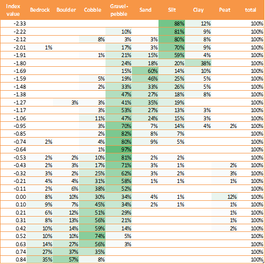
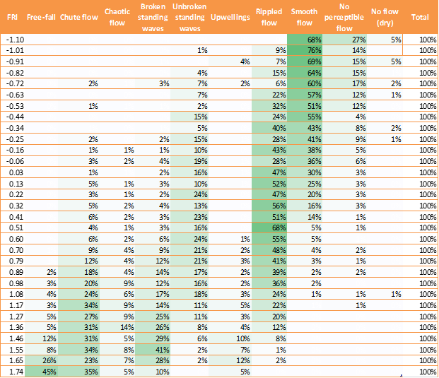
The four hydromorphological indices represent major dimensions in the distribution of hydromorphological features derived from RHS data. The following figures illustrate, for each index (x scale), the relative occurrence of constituting morphological features in percentage. The indices and figures were built using RHS semi-natural sites with little or no signs of channel/bank modification. For example, on the Channel Substrate Index figure and table below, a CSI score of -2.33 is associated with sites generally composed of silt (88%) and/or clay (12%).
Information on how to calculate indices can be found on the river habitat survey website: http://www.riverhabitatsurvey.org/manual/rhs-indices/
Additionally, you can download an Excel spreadsheet to calculate indices by hand: www.riverhabitatsurvey/RHSfiles/RHSHydromorphologicalIndicesCalculation.xlsx
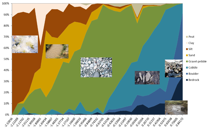
Below is the table on which the graph above is based. It shows the relative occurrence of channel substrate types with increasing CSI scores (proportion < 1% have been hidden).
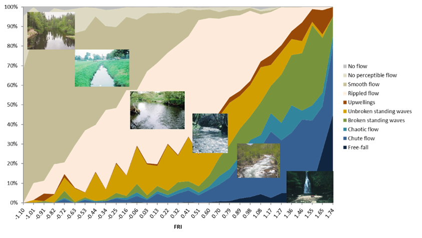
Below is the table on which the graph above is based. It shows the relative occurrence of flow-types with increasing FRI scores (proportion < 1% have been hidden).
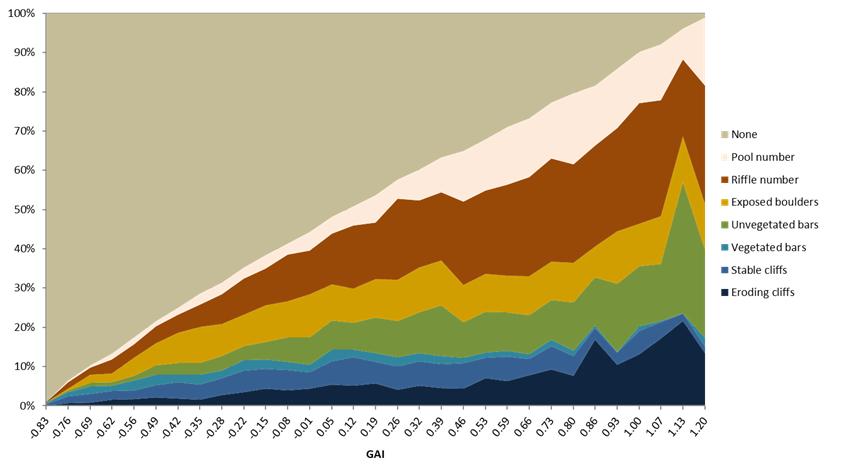
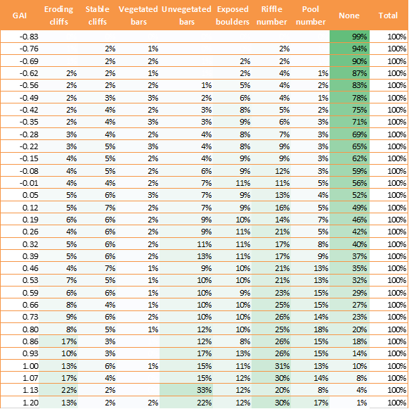
Below is the table on which the graph above is based. It shows the relative occurrence of geomorphic features with increasing GAI scores (proportion < 1% have been hidden).
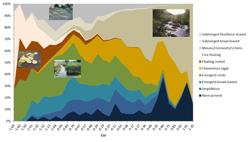
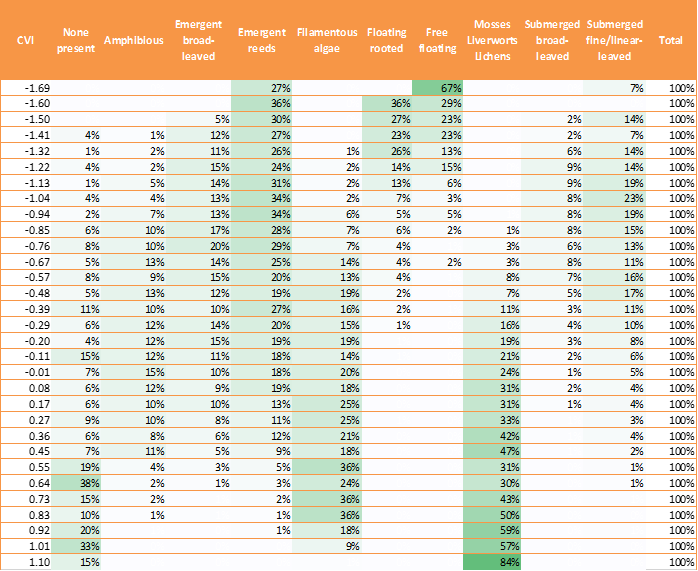
Below is the table on which the graph above is based. It shows the relative occurrence of channel vegetation types with increasing CVI scores (proportion < 1% have been hidden).
Morphological indices indicative score bands
The following score bands can be used to categorise the indices using thematic maps in GIS for example. The bands are indicative only and should be adapted to local context.
Channel Substrate Index:
Silt < - 1.81
Sand/Silt/Clay - 1.82 to - 1.17
Gravel/Pebble -1. 17 to -0.1
Cobbles -0.1 to +0.63
Boulder/Bedrock > +0.63
Flow Regime Index:
Step-pool <- 1.59
Cascades -1.59, -1.24
Rapids-1.24, -0.86
Riffles,runs -0.86, -0.22
Run, glide -0.22, 0.42
Glide, pool > 0.42
Channel Vegetation Index:
Floating < -1.23
Emergent-Submerged -1.23, -0.44
Emergent-Filamentous Algae -0.44, 0.26
Mosses-filamentous algae 0.26
Geomorphic Activity Index:
no activity < -0.79
very low activity -0.79, -0.66
low activity -0.66, -0.45
moderate activity -0.45, -0.12
high activity -0.12, 0.33
very high activity > 0.33