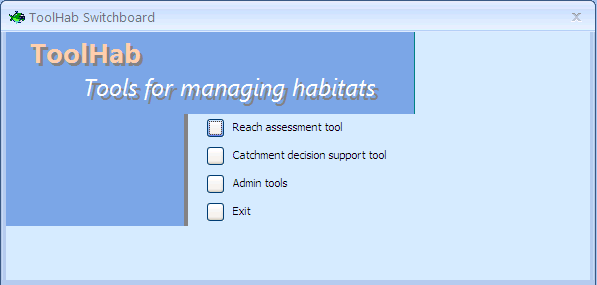
Switchboard options
The ToolHab switchboard has four options:
- The reach assessment tool option will open a tool for assessing individual river reaches. The tool gives users access to fisheries, biological, river habitat and water quality data along with maps and aerial photography. The data can be viewed for individual sampling sites but also at the scale of river reaches. Each river has been split into a series of discrete units representing homogeneous habitat sections. The tool also enables users to input their local knowledge using a simple interface. Historic information about river sections or individual events can be recorded and showed on map. The reach assessment tool was designed for Catchment Officers to help them identify pressures and impacts and suggest management actions. The tool is fully functional
- The catchment decision support tool summarises the information collected using the reach assessment tool at the scale of rivers (from source to mouth) or catchments. This decision support tool was developed for Technical Specialists within Environment Agency fisheries units to identify pressures and impacts at catchment scale and design strategies and programmes of measures. At the moment, this tool is not fully functional and is for demonstration purposes only. It will display information and enable to query GIS data but it will not enable a full assessment at catchment scale.
- The admin tools menu can be used to change the paths to aerial photo, maps and RHS photo directories and to perform an update of the database and help file.