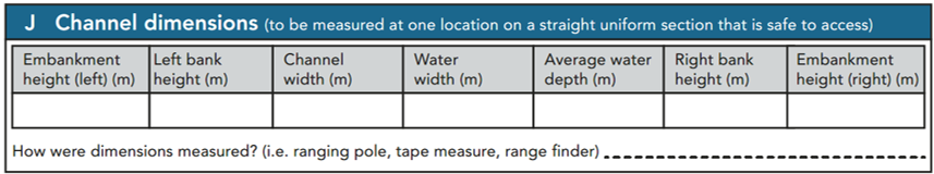
Section J: Channel dimensions
SECTION J: CHANNEL DIMENSIONS
Make sure that it is safe to enter the channel to take measurements if needed. For large rivers where mid-channel water depth cannot be safely measured, enter “unknown” in the appropriate box.
Page 3 of the form contains Section J – Channel dimensions. These are measured at one location of your choosing that is preferably straight with well-defined banks and a raised bed and shallow water within the 500m. Guidance on how to measure the channel is included in the mini-manual. Where it is safe to do so, the bank heights, channel width, water width and water depth should be recorded, preferably using the ranging pole. A rangefinder will be needed for estimating the width of larger rivers.
For guidance on banktop, water width etc., see the figure below. To ensure consistent recording it is imperative that surveyors fully comprehend this information before undertaking field measurements.
In some instances, the river bed will be inaccessible and consequently water depth will not be determined. If so, indicate accordingly on the form.
Rangefinders and ranging poles will improve the accuracy of measurements taken. Indicate how you measured the channel.
Measuring channel dimensions on braided channels can be very complicated due to the presence of several sub-channels. Water depth should be the average depth of water in the largest channel (i.e. the one from which flow-type and substrate are recorded in spot-checks), but water width cannot be measured. Banktop height and bankfull width should be measured using the banks abutting the floodplain.
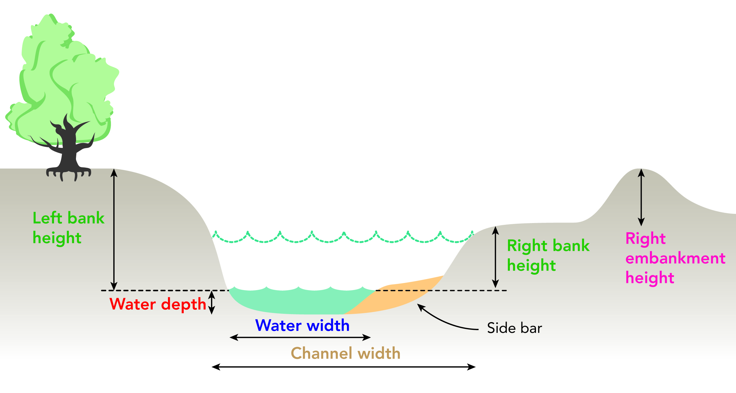
Embanked height (m)
Where embankments are present, record the extra height created by the embanked material. Include set- back embankments where practicable.
Bank height (m)
Bank height is the vertical distance from water level, to the first major break in slope above which cultivation or development is possible which we also call the banktop. Use the ranging pole to estimate height (m).
Channel width (m)
Channel width is the horizontal distance across the channel to be measured at the level where the river first spills out of the channel on to the floodplain.
Where no distinct breaks in slope occur (e.g. streams in vee-shaped valleys or gorges), the bank height should be estimated using clues such as the winter flood level, often marked by a trashline, or ‘notches’ along the bank at similar heights to the trashline. Make a note in section O
Water width (m)
Water width is the distance across the wetted perimeter of the channel. Use the ranging rod to make crossing the watercourse in shallow locations safer, and use the rod to help measure the width. When a range-finder is used to measure channel width, indicate by adding (R) with the width measurement entry. Note on them the max-min range of the range-finder used.
Beware: in misty conditions, or where the bank has a non-reflective substrate, accurate range-finder readings are difficult to get.
If it is impossible to wade safely across the river, and you do not have a range-finder, a reasonably accurate estimate can be made by sticking a ranging pole on the bank, and walking along the bank until the pole appears to be the same distance away as the far bank; pace the distance to the pole to estimate the channel width. Wherever possible, however, use a range-finder for measurements.
Water depth (m)
Water depth is the estimated average depth of the channel (to the nearest 0.1m). Where possible, always try to estimate the actual depth, using the ranging pole; otherwise use “not known”. Common sense should prevail, but recording the average of three measurements taken across the depth range is good practice. If access to the channel is considered too risky, estimate the depth if feasible; if in doubt, record ‘NK’ in the box.
How were dimensions measured?
Comment on how you recorded the channel dimensions i.e. using a ranging pole, tape measure or range finder.