Spot-checks
Conducting a cRHS survey
The animated picture below quickly describes the process of carrying out a cRHS. Surveyors start at the downstream or upstream end of the site and do their first spot-checks and take a video. They will then pace 50m and stop to do another spot-check and so on until they have completed 10 spot-checks. They then walk an extra 50m to the end of the site and carry out the sweep-up. Surveyors working in pairs should take photos of the channel and banks with a 360 camera every 5-10m along the entire site to provide a 360 degree virtual survey.
Spot-checks
Spot-checks are designed to record predominant channel, bank and river corridor features at 10 locations spaced evenly along the 500m cRHS site. Data for spot-checks are entered on page 2 of the form.
You need to record a short video at each spot-check using the following protocol (see also animated picture below):
- Position your self on the top of a bank
- Start the video facing and looking across the channel as when doing a normal spot-check assessment
- Name the spot-check number (e.g. ‘spot-check one site number one on the river Taff’)
- Direct the camera so that the water surface and the flow is visible and film for 10 seconds
- Slowly pan the camera so that it records the river and its banks on both sides as well as the floodplain downstream and then upstream.
- Take a few steps away from the bank and move sideways to capture the banktop and bankface of the bank on which you were standing.
Spot-checks should be located at regular (approximately 50m) intervals along the site. To do this consistently each surveyor should calibrate their stride length beforehand to identify how many of their paces represent 50m. It is best to use small strides – this tends to allow features between spot-checks to be observed and noted more comfortably. Adjustments may be needed, especially in difficult terrain because it may not always be possible to access the channel at precisely every 50m. Make a note on the form when this happens.
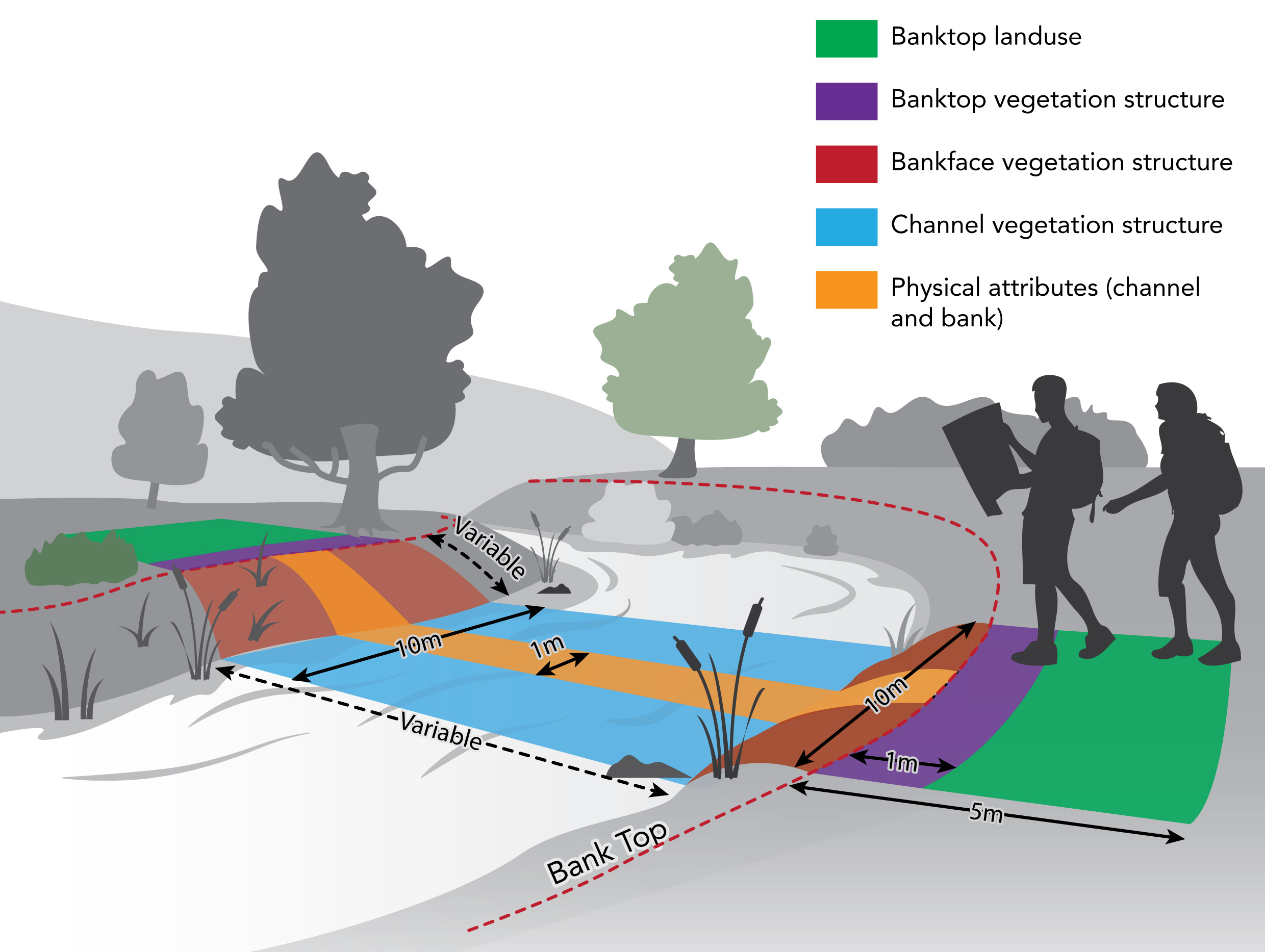
At each spot-check, information relating to the channel, banks and adjacent land is recorded. This includes: predominant channel substrate; habitat features; modifications to the channel and banks; channel vegetation types; vegetation structure of the banks and banktop; and land-use. Physical features (Section G) are assessed using a 1m wide “transect” across the channel, while all other elements in Sections H and I are assessed within a 10m wide transect across the river (See graphic below).
In Sections G and H, spot-check entries are abbreviations. Each entry must use the relevant unique two- letter abbreviation (e.g. BO = boulder; RI = reinforced bank). All abbreviations are listed as prompts on the form and are detailed in the spot-check key. Most are easily learned by surveyors, but having a laminated copy of the mini-manual or spot-check key in the field allows double-checking in cases of doubt.
For boxes in Sections G and H with emboldened borders, only a single entry is allowed. This is for recording the predominant feature only, even though there may be more than one present. Do not spend long deliberating over which option is the predominant one. Initial reaction is the quickest, and usually the best, method.
In boxes without emboldened borders more than one entry is allowed; for example, bank modification may include both poached [PC] and reinforcement [RI].
Section I provides a list of channel vegetation types; those present are recorded as either a ‘✓’ provided they cover at least 1% of the channel area, or as an ‘E’ if more than one third of the channel area within the 10m wide transect is covered. Records have to be made for each spot-check, including ‘none’ or ‘not visible’.
The primary reason for recording at spot-checks is to bring greater consistency of data collection. Each spot-check column should be completed in sequence. In most instances each spot-check should take no more than two minutes to complete, particularly since all emboldened boxes and most of the others too, will have just a single entry. For rivers with complex structure, spot-check recording may take a little longer – conversely, uniform watercourses will take less time.
It is essential that all boxes in Sections G and H (and at least one in Section I) are completed at each spot-check before moving to the next one. It is not possible to complete an acceptable cRHS survey if any of the boxes in Sections G and H do not have entries.