RHS Toolbox version 2 is out. It is the biggest update since the software was first released, and the first public release of version 2. Some of you will have seen it mentioned in last year’s post on Greek rivers, where it was described as “not yet available”. It now is.
The new version adds:
- the River Condition Assessment (RCA) used in England’s Biodiversity Net Gain, calculated from RHS data
- data entry, quality control and indices for the Citizen River Habitat Survey (cRHS), and the upgrade of citizen surveys to cRHS plus
- the Greek river typology, so HQA scores of Greek rivers can be compared with sites of the same type
- an online platform and map for sharing RHS and cRHS data, photos, videos and 360° photos
- a data analysis tab, an improved context analysis and new indices: width/depth ratio, a Channel Resectioning Index, and bank and riparian vegetation naturalness for RHS with Phase 1 surveys
Version 2 was developed with the support of Natural Resources Wales and in collaboration with the River Restoration Centre (RRC). Everything you know from version 1.5 is still there: RHS data input, quality control, HQA, HMS, RHQ, RQI, the hydromorphological indices and impact ratios, RHAT, and imports from RHS Mobile and RAPID. The full list of changes is on the What’s new page of the online help.
River Condition Assessment from RHS data
The Toolbox can now estimate the condition of any RHS site in your database using the River Condition Assessment (Gurnell et al., 2020). This is the method behind the river condition scores in the Statutory Biodiversity Metric for Biodiversity Net Gain. It scores positive features, such as vegetation structure, natural bank profiles and varied bed material, and negative ones, such as reinforcement, artificial structures, invasive plants and siltation. It looks at four zones: bank top, bank face, channel margin and channel bed.
The RCA was designed for MoRPh surveys. The Toolbox applies the same river typology, indicators and thresholds to RHS data:
- Desk-study indicators. Sinuosity, valley gradient and the other desk-study indicators are filled from map data and the RHS survey. Values you type in are never overwritten.
- River type. Bed-material indicators come from the recorded substrate and the predicted semi-natural substrate, so a modified bed does not change the river type. The RCA decision tree then suggests a type, which you can accept or change.
- 32 condition indicators. The spot-checks are grouped into five “pseudo-modules” to match MoRPh, sweep-up data fill the gaps, and feature counts can be rescaled to MoRPh survey length.
- Score and class. The Toolbox calculates the Preliminary Condition Score and the Final Condition Class, from Poor to Good, adjusted for over-deepened channels as the RCA guide sets out. Each calculation adds a dated record to the site comments.
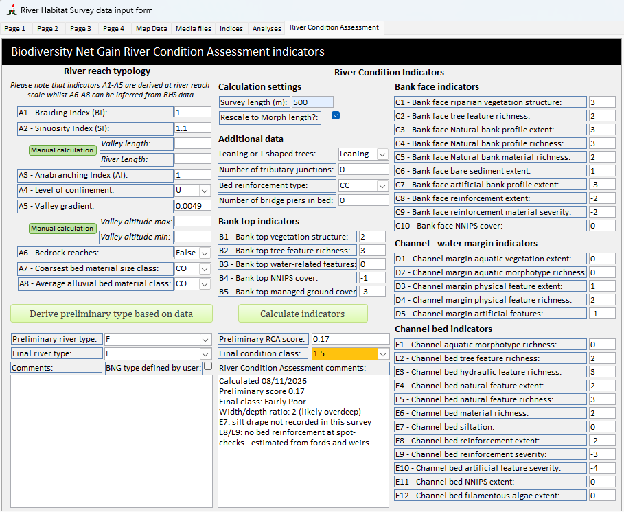
The results are RHS-based estimates of the RCA, not a MoRPh survey. Until recently, RCA outputs for BNG were produced with the Cartographer platform, but the Planning Advisory Service’s Deep Dive into Watercourses and BNG, reviewed by the Environment Agency, now states that using Cartographer is not mandatory. Ecologists may produce their own RCA outputs by applying the published, open-access RCA scores (Gurnell et al., 2020), which is what the Toolbox does. That page is advice to local planning authorities, not Government policy, and neither Natural England nor the Environment Agency has yet said whether survey methods other than MoRPh, such as RHS, are acceptable. Check the current Biodiversity Metric User Guide and with your local planning authority before using RHS-based scores in a BNG assessment.
In the meantime, the module makes it possible to look at river condition across existing RHS datasets, and to compare it with HQA, HMS, RHQ and the other RHS indices. We have done this for about 200 sites and will report the results in a separate post.
The step-by-step guide is on the River Condition Assessment help page, and Appendix 5 explains how each indicator is derived from RHS.
Citizen River Habitat Survey (cRHS)
The Citizen River Habitat Survey is a simplified RHS for volunteers and non-specialists. With a short training, they record about 75% of an RHS form along the usual 500 m site, and film every spot-check. They can also take 360° photos along the site.
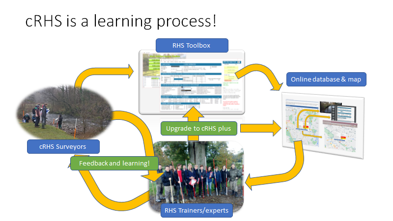
Version 2 has a dedicated cRHS data input form, with quality control and index calculation. It also imports data, photo and video links from the cRHS Android app.
From cRHS to cRHS plus
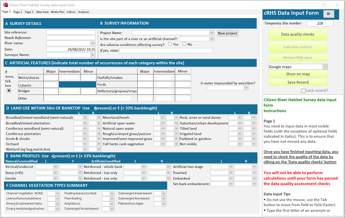
A citizen survey can be upgraded by an experienced RHS surveyor. Using the videos and photos, and talking to the citizen surveyor, they can add up to 15% more information. That is enough to calculate all the RHS quality indices and compare the site with similar sites.
The upgrade works through the online platform and map:
- The citizen surveyor uploads their survey, with open or restricted access.
- A reviewer downloads it, opens it as a full RHS form and completes it. A cRHS Review tab lets the reviewer and the surveyor exchange messages.
- The reviewer uploads the upgraded survey, which is marked as cRHS plus on the online map.
- The citizen surveyor downloads the upgraded version to their PC.
Reviewer status is given by the River Restoration Centre team to experienced, certified RHS surveyors. The process is described in the cRHS upgrade help page.
There is free cRHS training online on the RRC training platform.
Greek river typology
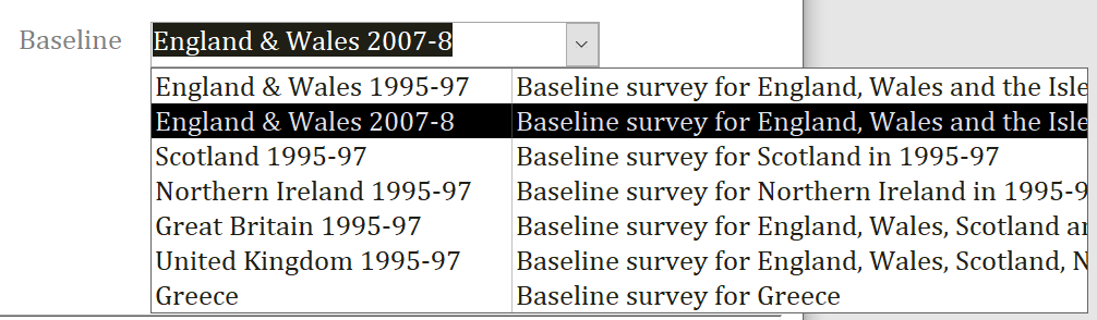
HQA scores only make sense when a site is compared with sites of a similar type. The Toolbox does this through a context analysis against a national baseline survey. Until now, those baselines covered only the UK and Ireland.
The Institute of Marine Biological Research and Inland Waters (IMBRIW) surveyed more than 300 Greek river sites with RHS. Their data are now built into the Toolbox as a baseline survey for Greece. Allocate a Greek river type to your site in the map data tab, and the context analysis compares it with Greek sites of the same type. This work is described in the post Expanding the Habitat Quality Assessment of Rivers in Greece and in the published study.
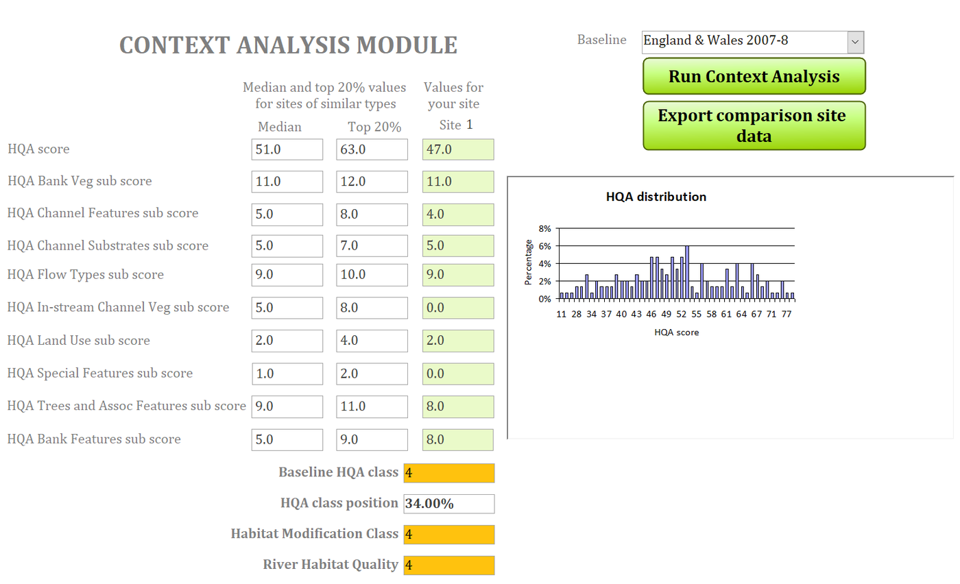
The context analysis itself has also improved. As well as the median for sites of similar type, it now shows the HQA score and sub-scores of the top 20% of sites. You can see where your site falls short of the best sites of its type, for example in channel vegetation or flow types.
If you hold a national RHS dataset and would like type-specific HQA classes for your country, please get in touch.
Online platform and map
We developed an online platform for RHS and cRHS with Natural Resources Wales and the RRC. It hosts cRHS learning material, a free online cRHS course, forms, the manual and a map of RHS and cRHS sites.
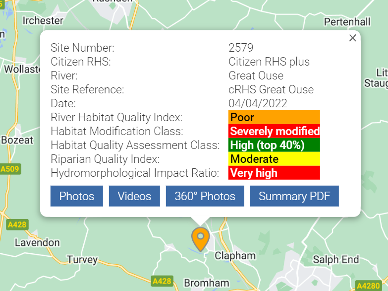
From the export menu, the Toolbox sends a survey online with its georeferenced photos, videos and 360° photos. Only surveys that pass quality control and have all indices calculated can be uploaded. Each site gets a permanent site number. On the map, it shows its quality classes, photos, videos, a virtual walk built from the 360° photos and a summary report. Before uploading, you agree to make the data and photos publicly available under a Creative Commons-based agreement.
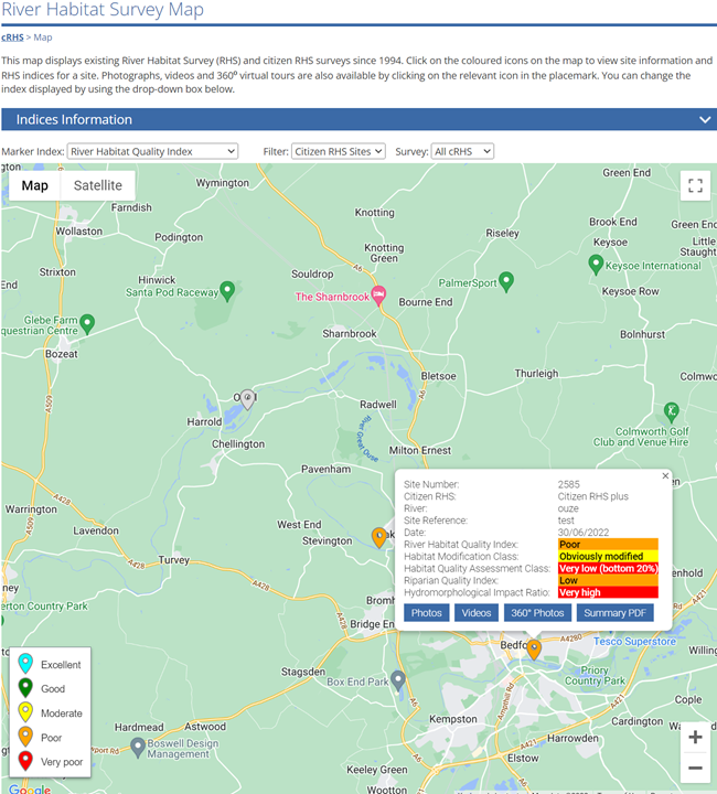
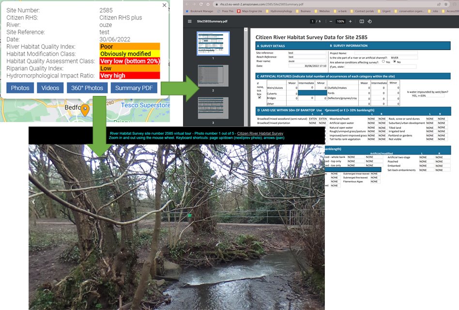
See Export online to the cRHS/RHS platform in the help for details.
Data analysis tab
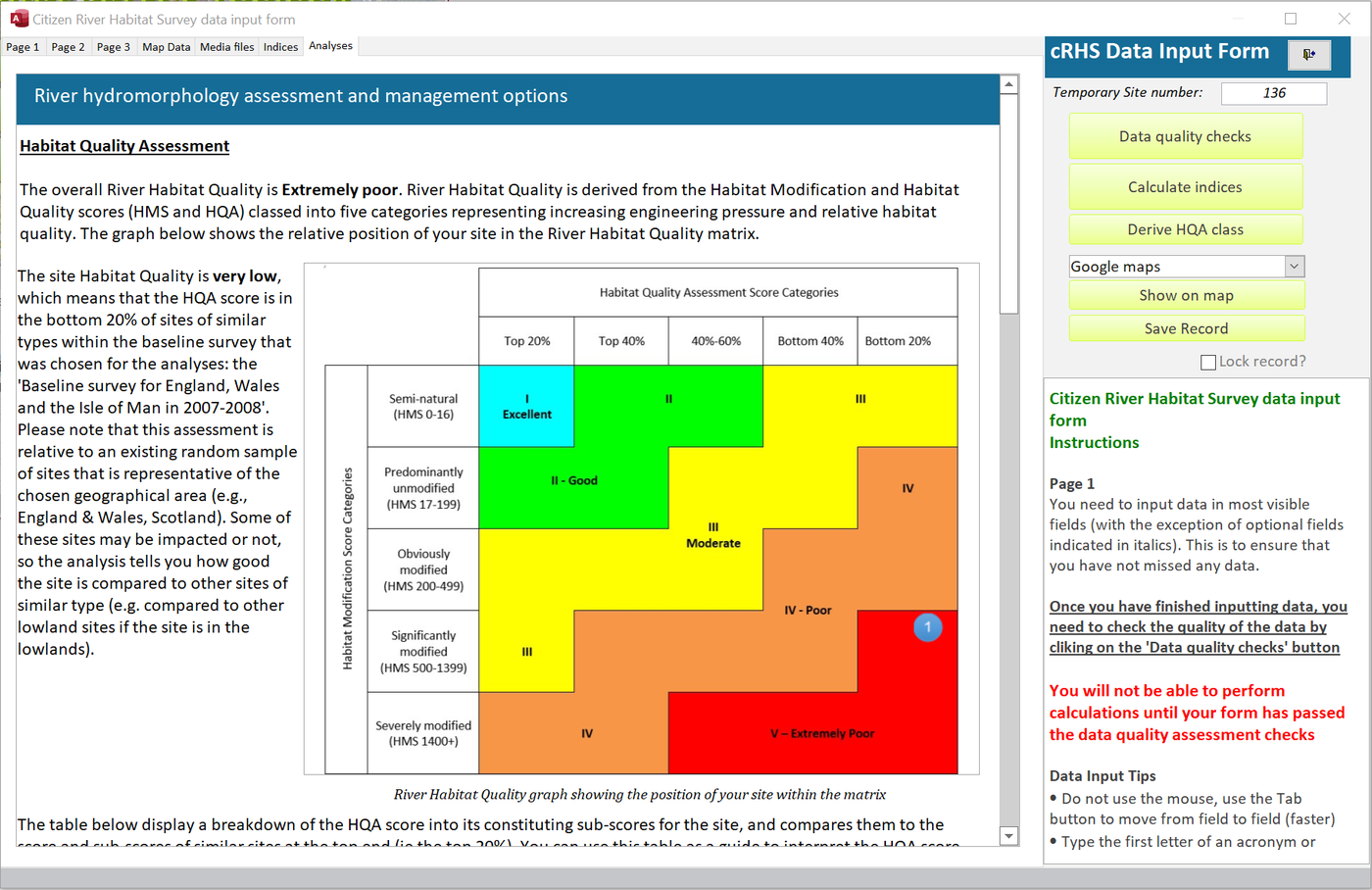
The RHS and cRHS forms have a new data analysis tab. Once all indices and a River Habitat Quality class are calculated, it gives a short report on the site’s habitat quality. It points out likely modifications, such as channel resectioning based on width and depth, and links to the RRC’s Manual of River Restoration Techniques and case studies. The report is also included in the survey printout.
Getting RHS Toolbox 2
You can download the RHS Toolbox and try it free for 30 days. It runs on Windows 8 to 11 with Microsoft Access 2013 or later. If you do not have Access, the installer offers a free Access runtime. See the system requirements.
After the trial, a yearly licence unlocks the advanced features:
- Business and public sector: £100 per year
- Charity, not-for-profit and self-employed: £70 per year
- Student: £30 per year
Licences can be bought from the Riverdene Consultancy website. If your organisation needs several users, please contact us. The full online help covers installation, licence activation and every module.
Many thanks to Natural Resources Wales, the River Restoration Centre and IMBRIW for their support. As always, we welcome your comments and suggestions for future versions.